New data: Britain under a lens as never before
From field boundaries to buildings, land cover to transport networks, the range of location data now available is hugely varied and shows just how much information about Great Britain’s geography can be revealed.
The new data and products are set to support customers across a range of markets, including the emergency services, sustainability, land management, transport, and land and property - in both the public and private sectors.
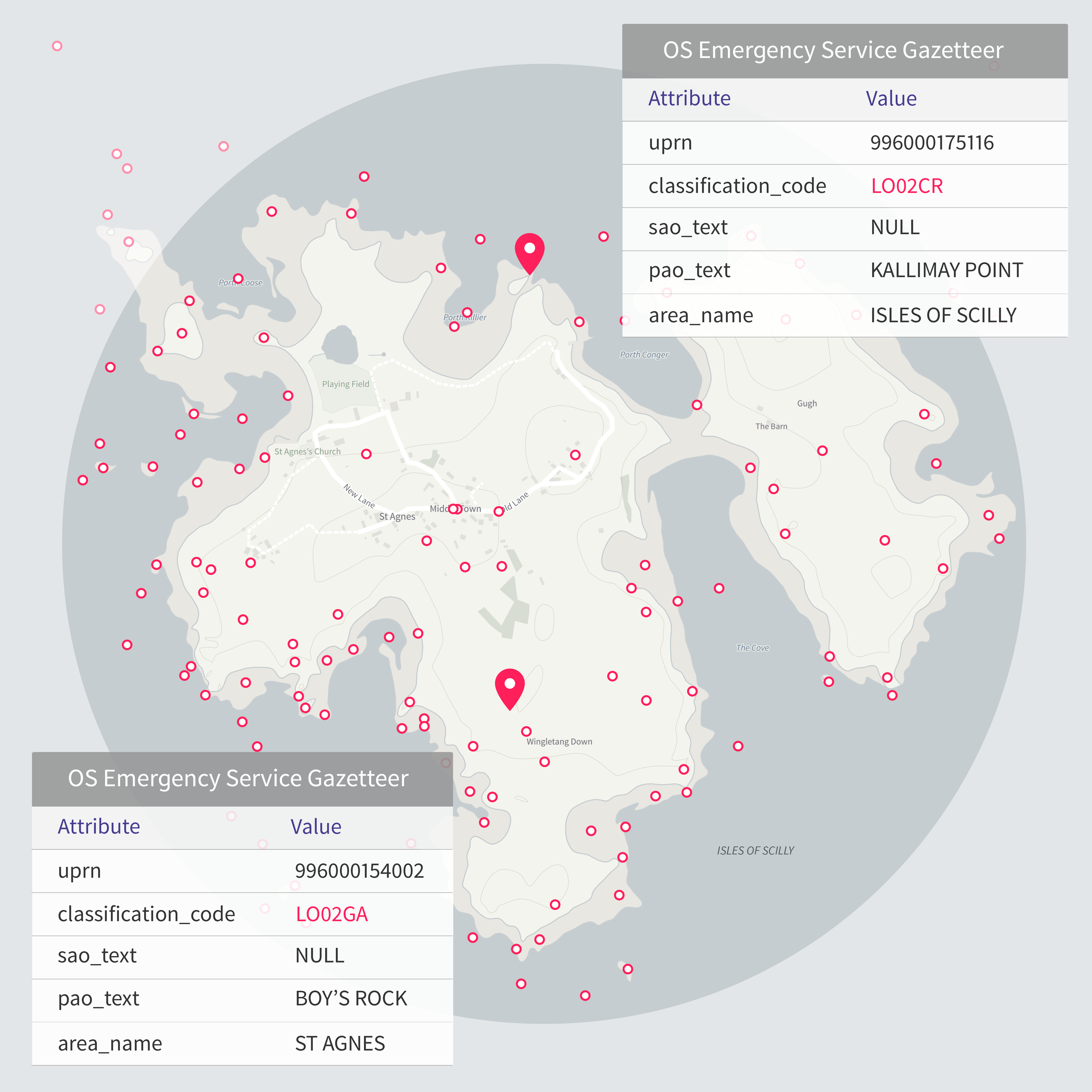
One of the new products is the OS Emergency Services Gazetteer (ESG), which will enhance the way that emergency services respond to and manage incidents. It contains 1.3 million features (names, places, and objects) such as motorway and road junctions and roundabouts. It can give responders (whether in the control room or on the frontline) the precise location information they need to act quickly to emergency calls, helping make Great Britain safer and more resilient. The OS ESG was keenly anticipated by and developed in close collaboration with the blue light community, and will continue to grow over time as new features are added.
The new OS Multi-modal Routing Network product has also been developed in response to customer feedback and brings all OS transport information together in one place, reducing the effort required in preparing the data for use in routing applications. The product fully integrates and connects over one million kilometres of existing OS Road, Rail, Path and Ferry networks in Great Britain, using more than 300,000 Modal Change Points (the sites where the transport networks connect) to show where you can transition between them. Local authorities will be able to use this data to plan safe routes to school and colleges, and emergency services will be able to improve their emergency planning for incidents at specific locations.
As well as these two new products, available in the OS Data Hub, more new data is available in the OS National Geographic Database (NGD), such as enhancements to OS Buildings, with new attributes to provide richer insights and greater understanding of risks to building structures and the surrounding population. The new data is expected to be vital for helping emergency services as it will give them improved situational awareness and insight.
Significantly, some of the new datasets will directly support the government’s priority to realise the full potential of public sector controlled data assets to deliver public services. It will also benefit environmental agencies, major landowners, and farmers. The field boundary data will help with understanding and assessing biodiversity net gain, as well as monitoring natural capital and carbon accounting. The new land cover enhancements will provide that consistent baseline of the natural environment.
"The government’s investment in location data has never been more important than it is now. These new datasets will quicken emergency response times and help local authorities deliver better public transport. The Geospatial Commission will continue to work on behalf of government with Ordnance Survey to improve the impact and value of location data in delivering public services."
The creation of the new datasets in the OS NGD and the two new products have used a range of different data sourcing techniques in addition to the traditional surveying methodologies, including elements of machine learning, data science, and partnering with third parties.
OS will continue to enhance its data, with the next release in September. There will be further OS Buildings data with information on the number of floors, delivering richer Land Use information, and adding data on what geographical features interact with bridges to continue supporting the emergency services.
Managing Director of National Mapping Services at OS, John Kimmance said:
“This latest release demonstrates the breadth and layers of information behind the map of the nation. Accurate and trusted location data has become a vital national asset in supporting many of the services which we rely on, from underpinning public services to enabling quicker emergency service response times, as well as helping to implement land and sustainability measures or managing our built environment. These new datasets provide even richer information to support customers with their existing and future operations.
“At Ordnance Survey we are continually innovating and investing in new ways to map the nation. It is great to see data in this latest release being produced using cutting-edge machine learning expertise. Our aim is to provide the most up-to-date and detailed information to our customers, and with the introduction of new technologies, alongside our expert teams, we can continue to do so.”
The new location data has been released as part of the Public Sector Geospatial Agreement (PSGA). The PSGA is a contract between the government and OS for the provision of geospatial data and services to the emergency services and wider public sector organisations.
All of OS’s location information is available to market through a range of products and services accessed via the OS Data Hub – which provides access to the data through both APIs and downloads.
Explore the OS Data Hub
With over 20,000 updates to our databases every day, you have access to a comprehensive and up-to-date set of authoritative data through the OS Data Hub
Sharing the latest news about OS. We can license you to use OS maps in print, online and film format. For more information and resources for journalists, bloggers and media professionals, email pressoffice@os.uk or call 023 8005 5565.