New data: Emergency services gazetteer will help build a safer Britain
The new product - which will essentially add specific and accurate location information for previously unlisted features - has been delivered by Ordnance Survey (OS) under the Public Sector Geospatial Agreement (PSGA). It has been in high demand and keenly anticipated by the emergency services, which have worked in close collaboration with OS to develop the Gazetteer’s database.
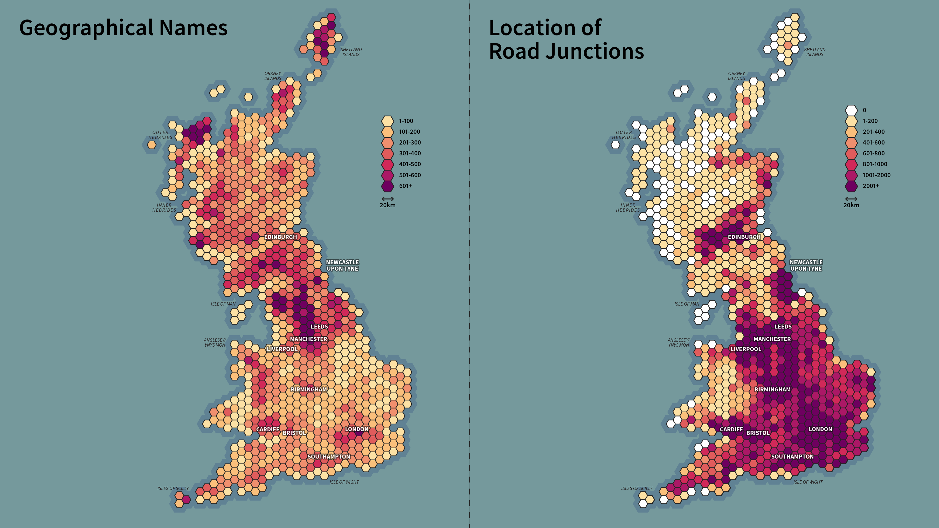
The OS ESG is a comprehensive and maintained database of locations. It contains 1.3 million features (names, places, and objects) such as motorway and road junctions and roundabouts. It is particularly effective in identifying the location of those areas that have no addresses, like named cliffs and named waterfalls.
The Gazetteer is designed to equip responders with the precise location information they need to act quickly to save lives and property during emergencies. It will provide a single, unified source of truth for accurate location information, aiding both those in control rooms and on the front line. It is a living, breathing resource, which will continue to adapt and grow after its launch as new information is added. The intelligent classification of the data will enable users to quickly filter and select different features of interest. The OS ESG has also been designed to work alongside our AddressBase Premium Product, which emergency services use every day.
"Ordnance Survey has a longstanding and close relationship with the blue light community and the new OS Emergency Services Gazetteer has been developed in close collaboration with them. We are looking forward to working with our blue light colleagues to implement the gazetteer and see how this enhanced data can support incidents by enabling locations to be identified and reached more quickly."
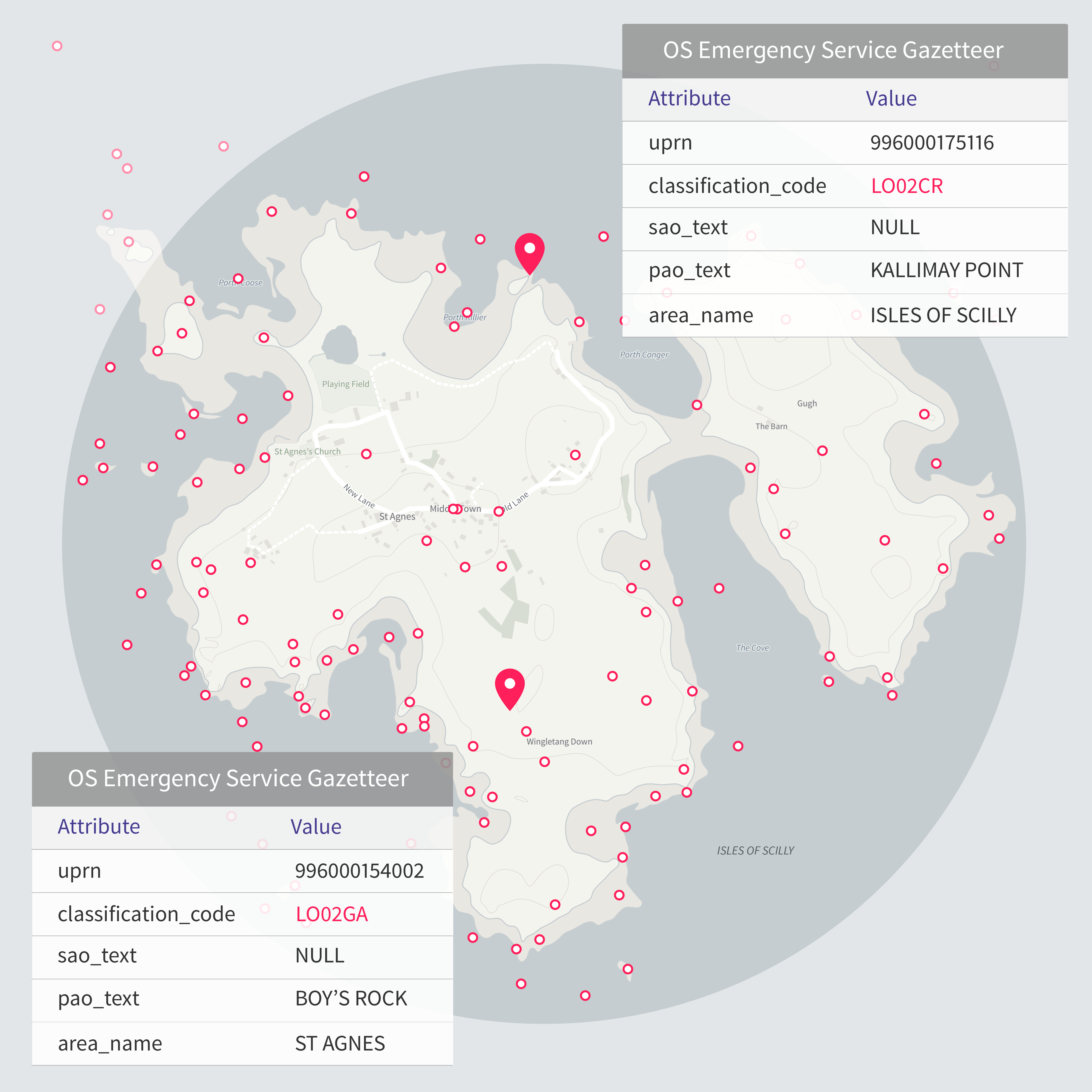
Within the OS ESG, users can search geographical names across the whole nation, including names of hills, waterfalls, valleys etc. Users can also search new layers of information on road junctions, including names and numbers of road intersections. In addition, every feature within the gazetteer will have a Unique Property Reference Number (UPRN) to improve data sharing and reporting.
The UPRN serves as a unique identifier for a location, applying a ‘common standard’ for addressable buildings and objects, which then makes it possible to collate, share, and connect data from various sources. The UPRN is already an established and trusted data tool relied on by the emergency services.
Jessica added: “Through our close relationships with the emergency service community we have identified where the OS ESG will make a difference on the top of the improved search. This includes areas of improved incident reporting such as traffic incidents, enhanced data sharing, better incident analysis and modelling, and overall operational planning.
“This is the first release of the OS ESG. I look forward to seeing how the product develops, but most importantly, seeing how it supports emergency service teams across the county to carry out their critical and lifesaving work.”
The OS ESG will be continually updated with users able to access monthly updates via the OS Data Hub. Future planned developments to the ESG will see greater specification and features added to the products. These include the addition of bridge interactions later in 2024, and features such as tunnels, slipways, vernacular names, motorway emergency phones, and marker posts from 2025.
In February 2024 Her Royal Highness The Princess Royal joined a selection of emergency service users to preview the new OS ESG at an Emergency Service showcase held at OS head office in Southampton.
"The most important question when someone calls 999 in a coastal emergency is: where? Understanding local geography can make a lifesaving difference to getting the right help to the right location, fast. Action might involve sending an HM Coastguard helicopter; Coastguard Rescue Teams trained in cliff, mud, or water incidents; or a lifeboat. When a caller isn’t sure where they are, knowing the lie of the land is vital for our Rescue Coordination Centres to pinpoint where and how to respond. We're very proud of how HM Coastguard helped trailblaze the OS Emergency Services Gazetteer which supports the work we and our fellow emergency services do every day."
OS provides its data and services to the emergency services and wider public sector organisations through the PSGA. The PSGA is a contract between the government and OS for the provision of geospatial data across multiple themes, including buildings, transport, structures, addressing and land. The contract delivers key data to public sector members for use in everyday settings to support provision of critical services to the public.
OS also remains on call 24/7 with its mapping for emergencies service, whether for a natural emergency or security threat.
The new OS ESG can be accessed via the OS Data Hub.
Explore the OS Data Hub
With over 20,000 updates to our databases every day, you have access to a comprehensive and up-to-date set of authoritative data through the OS Data Hub
Sharing the latest news about OS. We can license you to use OS maps in print, online and film format. For more information and resources for journalists, bloggers and media professionals, email pressoffice@os.uk or call 023 8005 5565.