What is authoritative data?
Data Management Specialist Nicole Frith takes a closer look at the ’Our Data Is Authoritative‘ principle and what this means for OS and our customers
I worked with the Geospatial Commission and the Geo6 (British Geologic Survey, The Coal Authority, HM Land Registry, OS, UK Hydrographic Office, The Valuation Office Agency) on the Data Discoverability Project, which formed part of a wider Data Improvement Programme. I was assigned to the ‘Enabling Authoritative Data’ workstream, which aimed to help people find geospatial data which they could trust within the ever-increasing volumes of data created and published every day.
What do we mean by ‘Authoritative Data’?
In my experience, both on the Data Discoverability Project and in my wider day-to-day work, the term ‘Authoritative Data’ is frequently used but often misunderstood.
Professional bodies and the literature, for example, provide several different definitions, all of which suggest the ‘authority’ of a dataset depends on mandates, certification or legislation, or its source:
Definitions of the term ‘Authoritative Data’
- Data provided by or on behalf of a public body (authority) which has an official mandate to provide it1
- Officially recognised data than can be certified and is provided by an authoritative source2
- Applied only to data that is legislated or regulated. Validation must be part of the certification of authoritativeness3
Definitions of the term ‘Authoritative Source’
- An entity that is authorised by a legal authority to develop or manage data for a specific business purpose. The data this entity creates is authoritative data.2
- A source of data or information that is recognised by members of a Community of Interest to be valid or trusted because its provenance is considered highly reliable or accurate.4
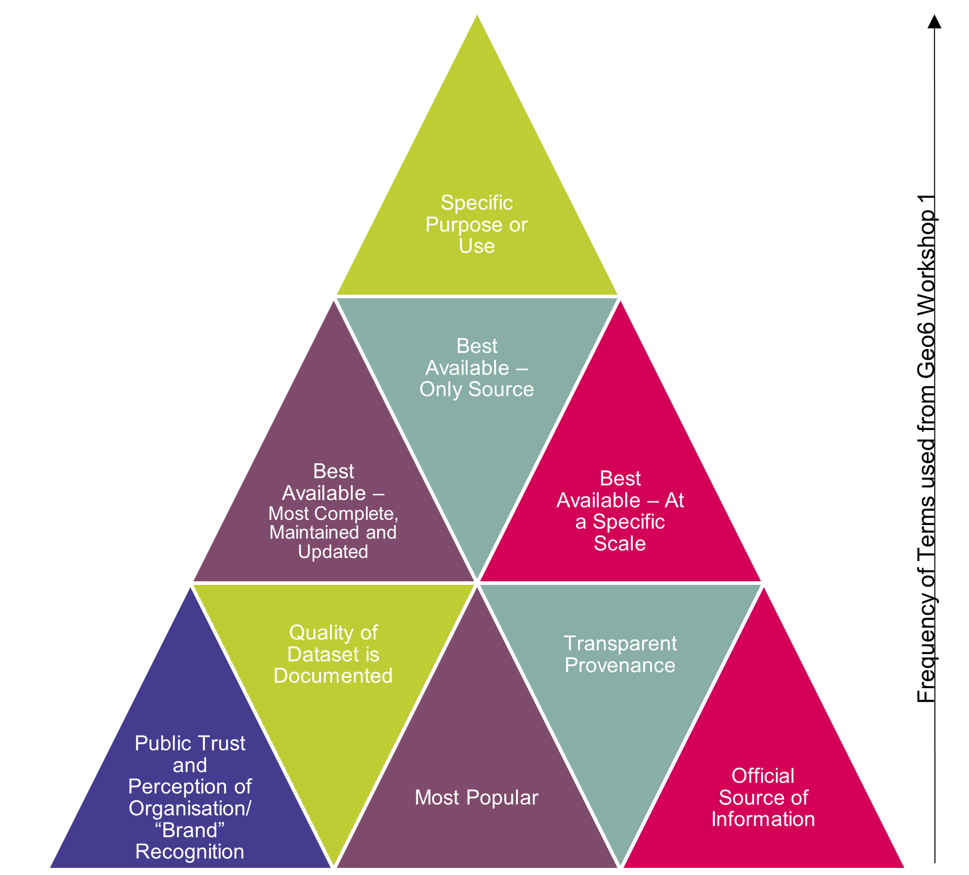
When we asked the Geo6 what the term ‘authoritative data’ meant to them however, responses were much more varied and included a much wider range of factors. These included (amongst other things):
- Public trust and perception of the organisation publishing the data
- The quality of the data
- Whether the data was the best or only source
- The purpose of the data and its fitness for that purpose
User research offered yet another perspective. As part of the Data Discoverability Project, we carried out a series of user interviews across a range of user archetypes, asking participants to complete several tasks that required them to find geospatial data. Over 70% searched for a government organisation, and a further 20% clicked through to a government organisation’s website. Some users commented that this was specifically due to government organisations holding trusted and authoritative data. When questioned further about this, data quality was provided as a common response.
What this means for OS
They say: “beauty”, or in this case, ‘authority’, “is in the eye of the beholder”. In my experience, we all have subtly different understandings of what authoritative data is and should be, however these are all underpinned by the common themes of confidence and trust.
The Ordnance Survey public task sets out what we exist to do, including in relation to the National Geographic Database (NGD) of Great Britain. As custodians of Crown geospatial data, the Ordnance Survey public task defines our responsibilities to create, maintain, improve and provide access to consistent, definitive and authoritative location data of Great Britain. This is delivered and governed through the Public Sector Geospatial Agreement (PSGA), which is funded by the Geospatial Commission to invest in the improvement of the data for the citizen.
However, “with great power comes great responsibility”. Data from OS is authoritative not just because of our public task. Its ‘authority’ is reinforced over time by continuous investment and improvement to a level of quality that meets our customers’ needs. Taking this more holistic view, all of the other factors identified by the Geo6 – quality, fitness for purpose, reputation – are not just important to our users but are fundamental assumptions by the users of our data.
With our public task comes an ongoing investment and valid expectation from our users, and indeed measured commitments with the Geospatial Commission, that our authoritative geospatial data is captured, curated and maintained to meet their needs. This in turn maintains our reputation and position as the authoritative National Mapping Service of Great Britain with a public task.
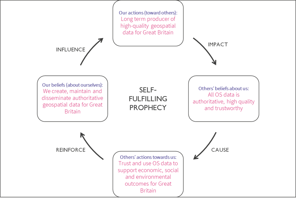
Together, our mandate through the public task, the trust and confidence that this affords our customers and data users and this idea of reinforcement over time, form what I visualise as a ‘self-fulfilling prophecy’ (figure 2).
As we transform our data to meet new and emerging customer needs, we must recognise and uphold all aspects of this cycle. We do, and must continue to, put data quality at the front and centre of our operations, to support and maintain our customers’ trust and support positive outcomes for Great Britain. If not, there is a risk that the whole spiral unravels, regardless of our public task.
OS data principle: our data is authoritative
At OS, we work hard to deliver authoritative geospatial data that is both useful and relevant to our customers, and we recognise and champion this within our Data Principles.
As we evolve to deliver new, richer data, we ensure we live up to this customer expectation with supporting policies and processes. We continue to invest and improve in the quality of our core geospatial data to meet our customers’ needs.
In today’s constantly evolving world, geospatial data is becoming increasingly ubiquitous and it is not enough to rest on our laurels or heritage. We must live up to and deliver against our customers’ expectations, and in doing so, continue to provide Great Britain with authoritative data which they can trust and use with confidence.
Continue the conversation
- What does ‘authoritative data’ mean to you?
- What datasets would you say are authoritative and why?
- Would you seek to find and use authoritative datasets and why?
Find out more about the Data Discoverability Project and the best practice guidance and tools for geospatial data managers we have published, or get in touch to share your thoughts through the Geospatial Commission, geospatialcommission@cabinetoffice.go.uk.
Find out more about our public task, our Data Principles and how we live and breathe them at OS.
References
- Eurogeographics, assessed by Jonathan Holmes, 2019
- Authority and Authoritative Sources: Clarification of Terms and Concepts for Cadastral Data. FGDC Subcommittee for Cadastral Data. (2008).
- Pan-Canadian Action Plan for GeoBase II and Collaborative Geospatial Architecture Working Group Final Report, taken from ESRI Canada Blog (2014), ‘What Does the Term “Authoritative Data” Really Mean?’
- DAMA Dictionary of Data Management, 2011
- Data Discoverability Report, Geospatial Commission, 2020
Sharing the latest news about OS. We can license you to use OS maps in print, online and film format. For more information and resources for journalists, bloggers and media professionals, email pressoffice@os.uk or call 023 8005 5565.