We're pleased to showcase a product that harnesses the potential of identifiers, which are used extensively throughout OS product offerings. To explain how the product came into being, we’ll begin with a brief overview of the identifiers that are integral to product:
OS MasterMap TOID
Ordnance Survey MasterMap contains nearly half a billion features, each of which is represented by a unique identifier allocated by Ordnance Survey, known as a TOID (TOpographic IDentifier). The TOID is unique to a feature throughout its lifecycle (if the feature no longer exists, it is retired) which allows users to identify that feature across all of the MasterMap offerings and also when appending users own data to these features.
Top tip
A TOID is allocated to a feature by Ordnance Survey with the prefix OSGB followed by either 13 or 16 digits. For example, OSGB0000045763621288. This should be treated as text (Varchar) not numerical (Integer) by user or database software. Any amends to the TOID will mean you cannot reliably use this on other Ordnance Survey products. We would therefore advise that no changes are made to the TOID either manually or by software.
In addition, we also provide identifiers in our addressing products i.e. UPRN’s (Unique Property Reference Number) and road & highways products i.e. USRN’s (Unique Street Referencing Number).
With the understanding of identifiers now established, it’s time to turn to the product itself. OS Linked Identifiers offers a product that holds these identifier relationships in one place. A user can search on one identifier and in return, receive results on other identifiers that are interlinked. The diagram offers some of the connections a user can make when submitting a query using the OS Linked Identifiers product.
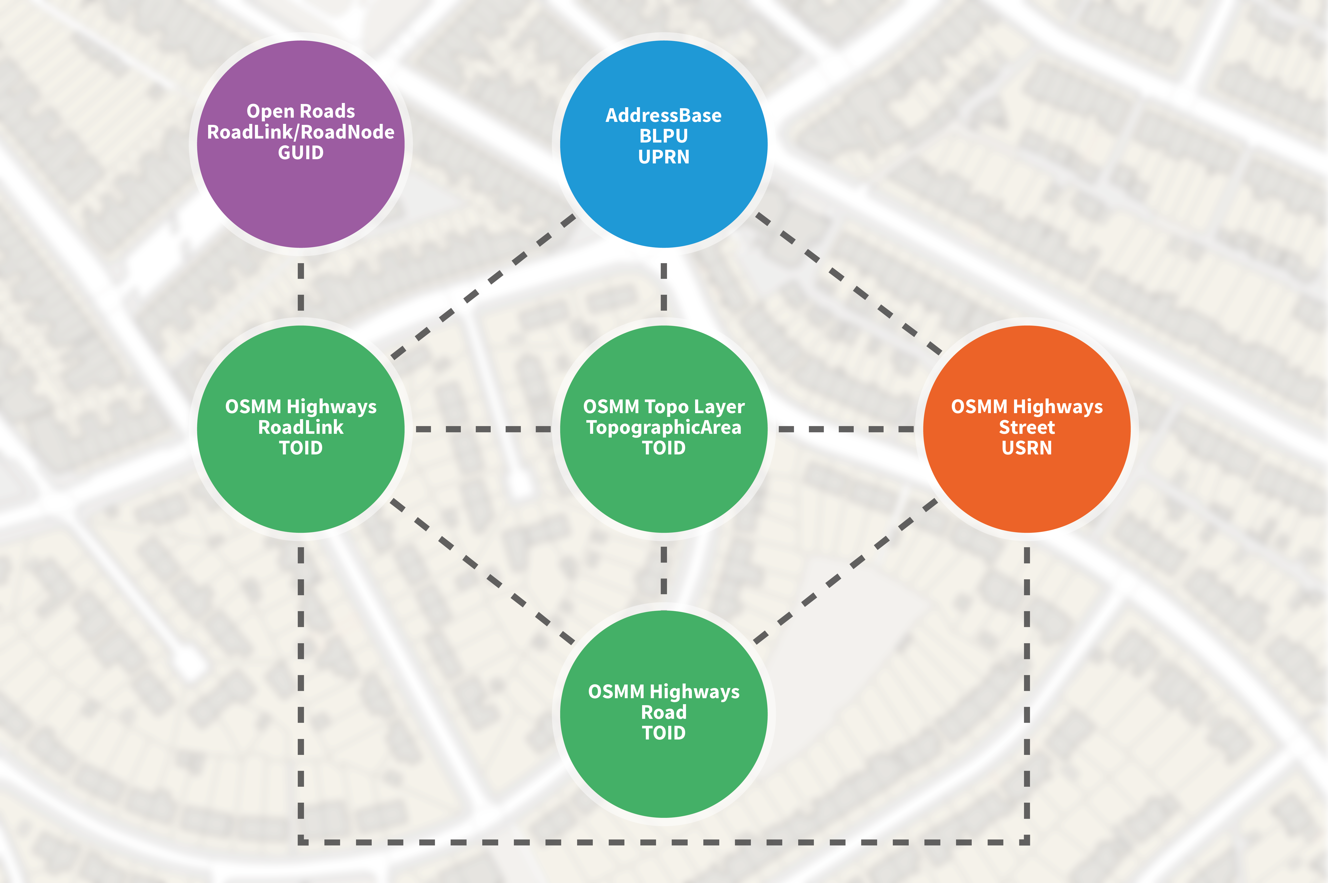
To provide context to where this product can be of huge benefit, let’s take an example of a risk management company providing location based risk analysis to the insurance industry. They have over 20 different data sources of environmental data, and require the ability to append this to individual property addresses for risk prediction for that location or grouped locations. Initially they can append the sources of data to OS topography features. But now with access to the OS Linked Identifiers API they can take the further step of linking to individual property addresses with ease.
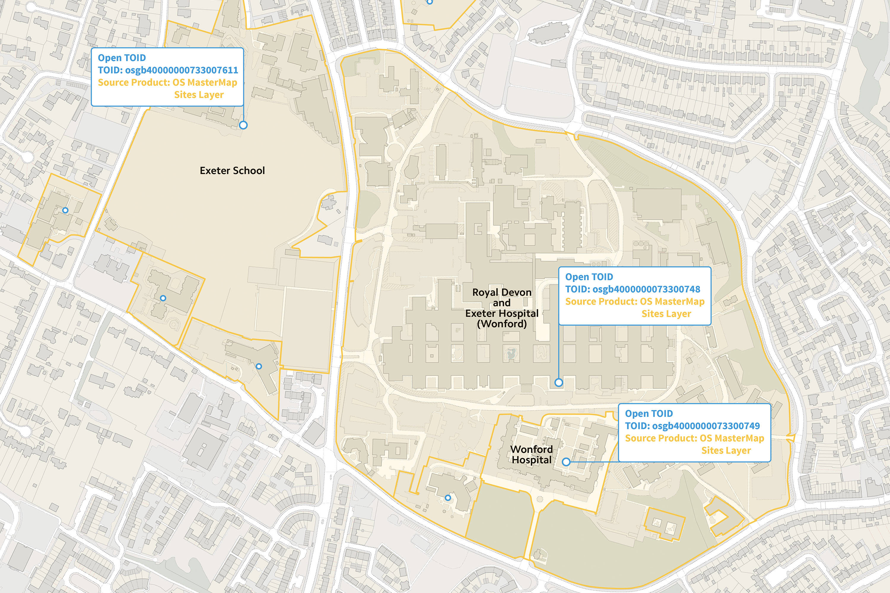
OS Open TOID
As the National Mapping agency offering the authoritative Topographic dataset of Great Britain, we recently launched OS Open TOIDs – effectively opening this data for all users. Our main goal is to embed this data into the wider geospatial network, not just exclusive to our public users or those paying for the premium sets in the public sector.
OS Open TOIDs also include location specific data derived directly from our premium products (in polygon shapes, this is generalised to the centre of the feature).
As Ordnance Survey continue to develop and evolve our data and products, these identifiers are at the very foundation of all of these plans. These are the one true consistent measure of a feature and by making these open to all and separating from our premium products, it opens up countless opportunities for us, users of OS data and those just wanting to append some real-world features to their data.
Find out how you can access and get support for OS Linked Identifiers, OS Linked Identifiers API and OS Open TOID.