2021 was a great year for OS Product Development and customers have enjoyed the benefits of a range of updates and improvements that have been made. Here’s a summary of recent developments to OS datasets.
We delivered new product formats, a brand-new dataset to signify useful relationships between our flagship products and a new data download mechanism that gives users more control and automation capability.
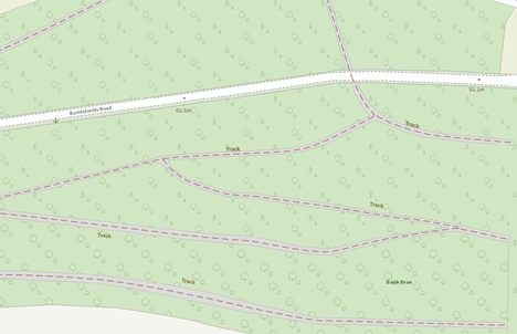
OS MasterMap Highways Network - Routing and Asset Management track coverage
An exciting update on the coverage of tracks within our OS MasterMap Highways Network - Routing and Asset Management product series. Previously, the coverage had been limited in extent and context, but with this major release, we anticipate an increase of over 2 million additions. Each arriving in batches according to the monthly release of the product. With the additions, we saw an uptick in attribution value such as segment length and elevation that added to the richness that users sought.
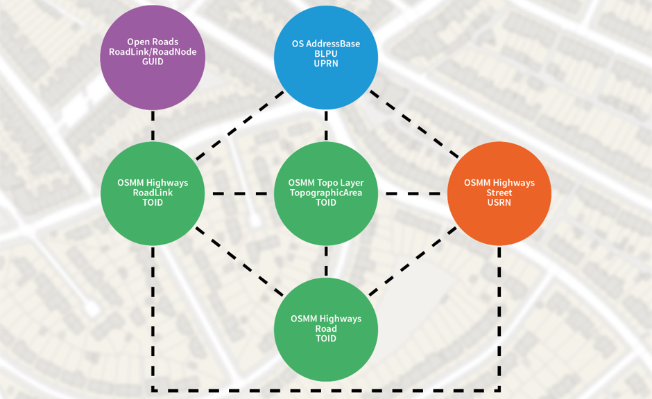
OS Linked Identifiers API
We launched new product called OS Linked Identifiers API. It didn’t go without notice that partners and users alike were keen to link OS product offerings with other, more notably, 3rd party datasets but found this cumbersome to embed. We realised it would be beneficial to release a product that holds OS product unique identifiers that are used and, importantly, establish their relationship. This unlocks insight by giving a user the capability to search for one identifier and open doors to discover other product identifiers that are interlinked on a geographical level.
OS AddressBase Premium GeoPackage Format
Customer feedback highlighted a desire for OS products in different formats, and GeoPackage was one of the most requested. Because we have forged new, and more convenient formats for users to access our high data volume products we released AddressBase Premium in OGC GeoPackage format.
This enabled users to consume our heavyweight products with the ease of ‘drag and drop’ functionality. Producing formats that are based on a standards-based approach with ‘platform-independent’ principles, is making the every day life of using our products easier and easier. Keeping the format to a single file, with no post processing necessary unlocks more time for a user to use the product in earnest and achieve their analysis goals quickly.
Find out more about GeoPackage and how you could benefit from AddressBase.
OS Downloads API
We have released our premium products to our download API offering titled OS Downloads API, after we looked into how our partners and end users download data. This gives more control to the user on what they would like to download and how often. The mechanism allows a user with the right tools, a way to identify which data packages are available to download, requesting metadata and then when content with their choice, scheduling the download to commence as frequently as they wish. As well as providing convenient formats, this download mechanism speeds up processing of our data.
2022 Formats & Beyond
What is there to look forward to in 2022 and 2023?
Well, there will be more product portfolio released in formats such as GeoPackage. And other new formats including Vector Tiles & GeoTIFF making an entrance. Plus, we have some very exciting news on refreshed ways to access OS data – watch this space!