New data: Ordnance Survey helping to protect Britain's landscapes
Press Office
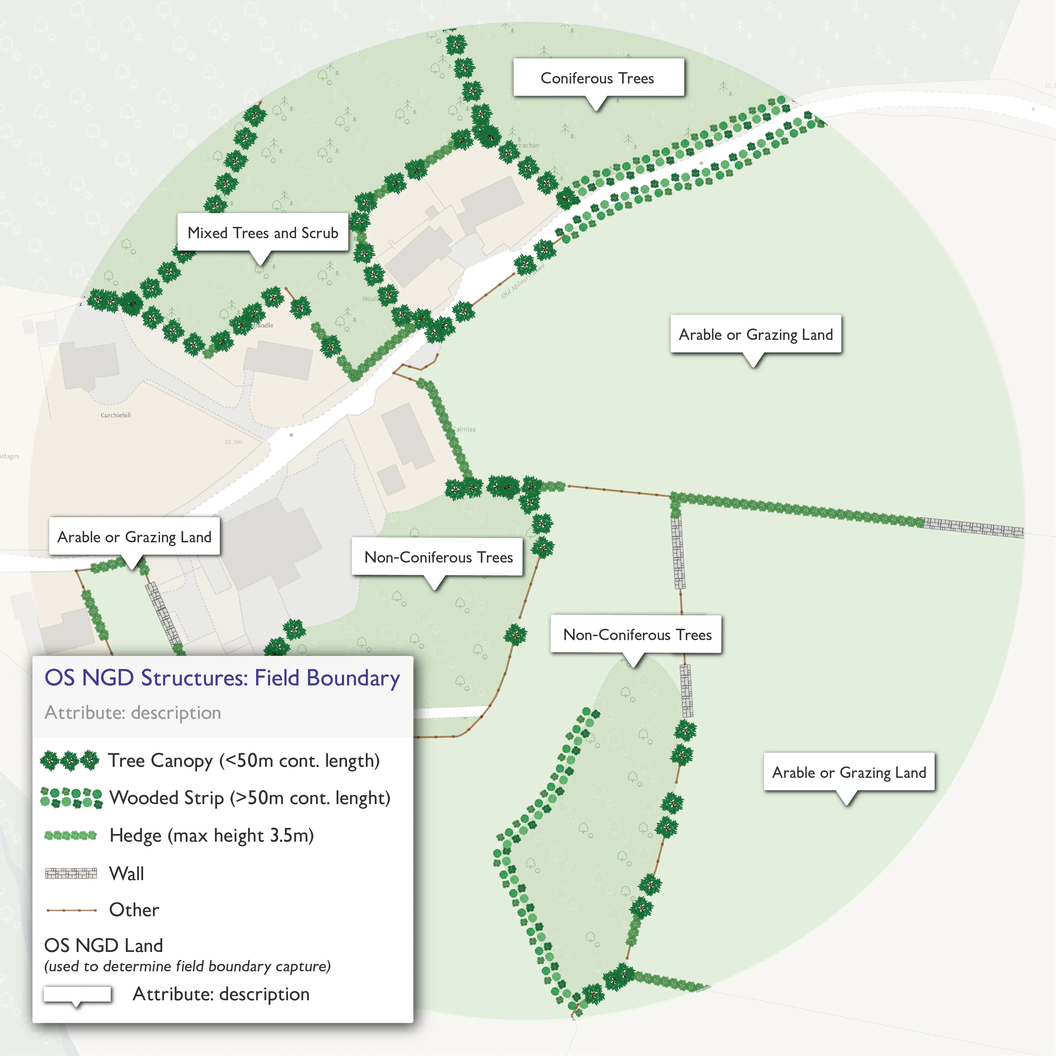
Field Boundary
The new Field Boundary data covers both rural and moorland areas across Great Britain and identifies the nature of field boundary features, for vegetated and manmade features such as hedgerows and stonewalls, captured through an automated process. Other characteristics are also included in the dataset such as the height and width of vegetated field boundary features.
Use cases range from understanding and assessing biodiversity net gain, to supporting Environmental Land Management Schemes, which have to monitor natural capital, and for carbon accounting. It will also allow the identification of wildlife corridors and pollinator networks.
The Peak District National Park will use the new data to monitor changes to one of the UK’s best landscapes – tracking the current picture against OS’s mapping of the park from the 1950s.
Up until this point, the Park’s field boundary data could only be acquired through visual interpretation of aerial or satellite photography, or site visits carried out on a case-by-case basis. This required considerable resources, and therefore did not allow for monitoring boundary changes at a landscape scale.
"If we understand the condition of the national park’s landscape, we can protect and preserve those valuable landscape features – a process that can be replicated by other national parks. The new Field Boundary data is fantastic. The OS National Geographic Database (NGD) makes it accessible, easy to work with, and the data just keeps getting better and better – with so many applications for it. For example, we are currently leveraging this data alongside MapReader software. Working with the Alan Turing Institute Living with Machines project we are able to quantify historic landscape features and compare them with present day NGD data."
This new Field Boundary data is beneficial for a range of environmental sector customers, such as the Rural Payments Agency, in supporting agricultural subsidy payments, environment agencies across England, Scotland and Wales, major landowners and farmers, as well as both local and central government in delivering net zero ambitions.
OS Land Cover
OS is also enhancing the land cover information in the OS NGD, by linking to habitat classification schemes and providing percentage coverage information for natural land cover features. This will provide a consistent baseline of the natural environment that supports customers with habitat monitoring. The land cover enhancements cover natural land cover features across Great Britain.
These enhancements allow for three main benefits: environmental monitoring and regulation of protected habitats, identifying areas for land management schemes, and evidence-based policy making and delivery. On the environmental side, protected (and other) habitats can be monitored, and allow for the understanding of land cover change for statutory reporting purposes. It can also facilitate the calculation of carbon storage, and the monitoring and management of climate change resilience. In addition, the enhancements support land management decision-making to identify suitable areas for nature-based solutions, as well as shaping future environmental policies and targets. It uses machine learning to calculate percentage values for natural land cover types – which are beneficial for environmental sector organisations interested in increasing biodiversity net gain and meeting net zero targets.
The data also aligns 33 OS Land Cover classifications to recognised classification schemes – these are European Nature Information System (EUNIS) and UK BAP Broad Habitats. For example, OS’s land cover classification of ‘Coniferous Trees’ is mapped across to EUNIS Level 1 as ’T: Forest and other wooded land’ and EUNIS Level 2 ‘T3: Coniferous forest’.
"Sustainability and net zero goals are more important than ever before, and these data enhancements will support organisations meet their commitments by providing them with greater insights into Britain’s natural environment. Having a deeper understanding of the locations of hedgerows and the land cover surface across our natural environment will have a significant impact on a variety of biodiversity activity and we are delighted that OS can play a role in supporting this."
All of the new data above sits within the OS National Geographic Database (NGD), accessible through the OS Data Hub. It is available to customers both via commercial terms for OS Partners, and for free to Public Sector customer through the PSGA.
OS provides its data and services to the emergency services and wider public sector organisations through the PSGA. The PSGA is a contract between the government and OS for the provision of geospatial data across multiple themes, including buildings, transport, structures, addressing and land. The contract delivers key data to public sector members for use in everyday settings to support provision of critical services to the public.
Users can access the OS NGD data via the OS Data Hub.
Sharing the latest news about OS. We can license you to use OS maps in print, online and film format. For more information and resources for journalists, bloggers and media professionals, email pressoffice@os.uk or call 023 8005 5565.
Explore the OS Data Hub
With over 20,000 updates to our databases every day, you have access to a comprehensive and up-to-date set of authoritative data through the OS Data Hub