May 2021
For this month’s article, we are going to explore how users can obtain hidden insight from attributes contained within our premium digital mapping dataset, namely OS MasterMap Topography Layer.
For a reminder, this dataset is positioned as our large scale, national geographic dataset that holds a vast array of features including (but not limited to) building footprints, points of interest, street & road information, water bodies & the underlying topographic landscape such as contours. This product is rich with insight as it can drive immediate value with it’s comprehensive size and accuracy but what is less known is how it’s inherent attributes are enablers for linking data and building calculations that at times, can be more insightful than simply visualising the feature location. A great example of unlocking this hidden value is to use the OS MasterMap Building Height Attribute enhancement product that forms the OS MasterMap Topography Layer.
For the remainder of this article, we'll look at a use case of a neighbourhood regeneration programme that need to demolish a block of flats to continue the project. A construction company have been instructed to carry out the demolishment however for the buildings to be removed safely, they require an accurate assessment of the volume occupied by all the buildings. This will aid in ordering the correct amount of relevant explosive material.
For the construction company to ascertain the volume, they have offered the following statements:
- We will need accurate area dimensions of the building footprint.
- We will need the building height between the ground & flat lined roof.
- Using the above information, we will be able to calculate building volume.
- We will finally need to identify what other features are near to the buildings so that we can assess any potential risks of damage.
Now let us review potential answers to these statements as below:
We will need the accurate area dimensions of the building footprint.
Using OS MasterMap Topography Layer, the construction company can make use of the ‘CalculatedAreaValue’ attribute that is provided as standard for every building feature in the dataset. This value is provided in m2 and in this example, we have the following values for each of the 6 buildings:
CalculatedAreaValue
627.78
538.85
538.64
459.73
453.73
385.42
We will need the building height between the ground and flat lined roof.
As the construction company have already made use of the OS MasterMap Topography Layer, they can also make use of OS MasterMap Building Height Attribute. This enhancement enables the user to attach height information to building features by way of matching against the TOID value. As part of the enhancement, there are various height values that relate to parts of a building as demonstrated below:
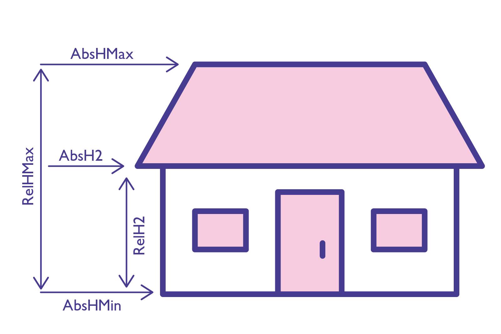
We'll be making use of the ‘RelH2’ value as this will give us the height from ground level to the base of the flat roof. This gives the following values for each of the 6 buildings:
RelH2
14.3
10.2
10.1
10.0
26.0
16.1
Using the above information, we will be able to calculate building volume.
Now we have both sets of values for each of the buildings, we can do a quick multiply calculation to obtain the volume in m3 as below:
BuildingVolume
8,977.29
5,496.31
5,440.23
4,597.29
11,797.09
6,205.19
We will finally need to identify what other features are near to the buildings so that we can assess any potential risks of damage.
Helpfully, as the construction company has already started to make use of the OS MasterMap Topography Layer they can make further use of the feature rich information by analysing other features in the vicinity that could be in the ‘at risk’ category of damage such as street furniture, infrastructure & other residential buildings.
Find out how you can access OS MasterMap Topography Layer, or OS MasterMap Building Height Attribute.